|
|
|
 |
 |
 |
 |
|
|
|
|
|
|
|
|
The Pacific Crest Trail
Mojave to Kennedy Meadows
Thursday, May 25: Day off in Mojave @ 2 miles
Friday, May 26: Golden Oaks Spring — 16.1 miles (579.8)
Mojave turned out to be a good resupply town, but we were soon ready to leave. The busyness of the highway that is the main street of town, the incessant wind, and the ugliness of the fast food franchises had me more than ready to go back to the peace of the desert. On the other hand, we ate well, the grocery, laundry and post office were fairly close, the motel was nice and the owner friendly (he drove us back to the trail this morning), so it was a good stop. John and Cyclone, Sundance, Drew and Emily showed up Wednesday evening, and Doug, Christa and Monty came in this morning. Evidently the others all went to the town of Tehachapi, the other direction on Highway 58 and the Tehachapi-Willow Road. There was a train wreck at the trail crossing of the highway on Wednesday afternoon. Evidently something toxic spilled, so they closed the highway — after we passed by fortunately. Traffic was a real mess with the highway closed. All the cars and trucks ended up going through Mojave on alternate routes — a total zoo. I was worried that some of the other hikers might get caught up in the mess, unable to get a ride to town because the highway was closed, but it seems that everyone went into town at the earlier crossing. We had chosen to come into town at the highway because it sets us up better today. I’d rather go 16 miles to water than 24!
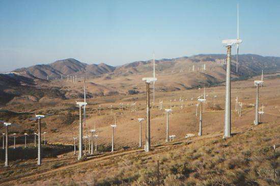
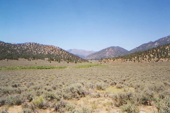
The trail this morning followed the freeway a while, then switchbacked up and up to the hills above. We can look south to Mojave, west to Tehachapi, and both directions to wind farms. It is hazy, so the Mojave Desert is indistinguishable beyond. A storm passed over on Wednesday, bringing high winds and cooler temperatures. Sitting at lunch in the shade of a pinion, I am actually cold. At least the winds aren’t as strong as they were in town, though one narrow ridge had me feeling a bit nervous as I was lurching across.
I feel good. We have the trail to ourselves. We’ll have a couple of short days in this stretch. Water is mostly 16 — 18 miles apart, and besides, we can’t hurry or we’ll reach the post office at Onyx on Memorial Day. For now we can take our time and enjoy ourselves, without feeling pressed to do longer mileage days. It is also our anniversary today, and I feel very blessed in so many ways: in my marriage, in my life and lifestyle, to be here on the PCT, to be open to the beauty around me —so many blessings. I seem to have come to terms with the PCT, what it is, and what it isn’t. In any case, I’m much happier than I was the first couple of weeks.
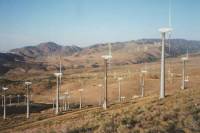
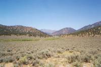
Later: We’re actually camped by water, a rare experience. I was able to wash up and get cooking water straight from the pipe. What a luxury! It’s so nice not to have to haul it for miles. The afternoon had more climbing, then winding around the hills on trail and a jeep road. The land is chaparral with occasional pine and oak, mostly very dry, but high enough in elevation to have some trees. We passed a big windfarm and are camped under a ridge covered in windmills. We can see their shadows on the trees in front of us, and we can hear the gentle roar of the turning blades. It is quite cool because of the wind and the altitude (6000’). We saw three trucks full of BLM people, and a land rover when we were on the jeep road. I don’t know why they were there. There were at least 10 people, but they were friendly, offering us water. We’ve seen no thruhikers, but then I think most went into town from Tehachapi Willow Springs Road, not Highway 58, so we’re about a half day ahead of them right now. A few may jump ahead though. I’ve noticed that most of the hikers around us have lost patience with the trail and are no longer following it blindly. There are a lot of short-cuts and alternate routes, if you look for them, and people do. It makes things more interesting, when you choose your own route, and the circuitous routing of the PCT gets very wearing. The guidebooks encourage taking alternate routes with their constant denigration of the trail corridor. They constantly tell us that the trail route is a bad one, and this or that alternative would be so much better. I hate the tone of the books, but sometimes I have to agree, despite my irritation at their negative attitude. The rocks and ridges around here are pretty though — lots of red and orange rock, some banded in white. Aside from the windmill farms, it looks pretty wild. I like it.
Saturday, May 27: Ridge above Cottonwood Creek — 19.3 miles (599.0)
It was a mixed day, with some very hot climbs through scrub oak and dense brush, and some cool contouring in the shade of black oaks and Jeffrey pines. We continued walking through the wind farm off and on for a couple of miles, then happily left the intrusive presence of the windmills behind to climb into the Paiute Range. The views were nice, when we had them. Around noon we ran into three trail maintainers: Pete Fish, Don and another whose name I didn’t hear. They’ve been out on this stretch for the past seven days, mostly doing brush work. We ate lunch with them. They are very dedicated, working off and on all year in southern California, with a break in late summer. They’re retired, now working as professional volunteers.
Later on we took a long break in the cool of some pines, napping and watching the sunlight dance on the trees. We saw bear, deer and coyote tracks and ran into lots of cows. We had dinner by Robin Bird Spring, then moved on afterwards because the maintainers told us that there was a bear hanging out at the spring. There was a nice, albeit hazy, view there. They were rebuilding the spring, but it was still usable. We’re both more tired than we should be at this mileage.
Sunday, May 28: campsite in the rocks @ 22 miles (621.9)

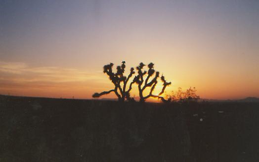
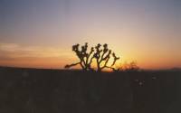
We started the day in cool pine forest, then descended back to high desert. Lunch was in the shade of a Joshua tree. (NB: They aren’t trees, and don’t provide much shade, but sometimes, that’s all there is.) We were supposed to detour to water, a mile and a half off trail, but some kind trail angel left several gallons of water for PCT hikers. It is about 29 miles from here to the next on-trail spring. The country was very pretty earlier, with views north to Owens, Jenkins and Olancha Peaks, plus one snowy ridge that could be Whitney. Down in the desert, it was dry, hot and windy, but with lots of flowers: yellow Fremontia and brittlebush, blue and white lupine, orange paintbrush, pink prickly pear, purple penstemon, plus a couple of new pink ones. We did well this morning.
We stopped to talk with one man and his son in a truck on Paiute Mountain Road and heard a few dirt bikers nearby, but never saw them. Too bad, as I’ve a lot of choice words for them. I’ve really developed a hatred for the dirt bikes and the destruction they cause so easily and casually. I almost stepped on a rattlesnake when I stopped to take a picture. Scared both of us! We saw more bear tracks this morning, but still no bears. No hikers either. Mule and Dave are now two days ahead. They are strong fast hikers, whose motto has become, “the death march continues!” There are only about 10 people ahead of us, supposedly. We’ve passed 20 or so, plus several who got off the trail for one reason or another. Some will catch up while we’re in Lone Pine, but it’s odd to be so alone after meeting so many hikers in the first weeks. I miss them, but not enough to slow down to try to get on their schedule. Soon enough the fast hikers behind will start catching up. There is a huge group that started a week after we did. Since we’re not particularly fast, they’ll pass us, sooner or later. In the meantime, I’ll enjoy the quiet.
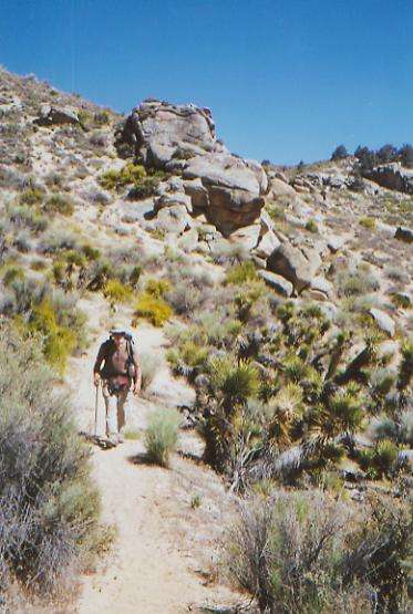
Later: It was a long, hot, dry afternoon. When our shade disappeared, we headed out over the dry hills around Mayan and Pinion Peaks. We took a long break in the shade of a pinion pine, the first shade in two hours. Then we trudged on in the heat of the desert. We finally stopped on a ridge covered with big boulders. There is a little flat area, one of the few we’ve seen on this roller coaster section of trail. There are lots of side trails and roads, heavily used by ATV’s and dirt bikes. They use the PCT too, (illegally) but we didn’t actually meet any today, just saw their fresh tracks. Jim and I are both tired, thirsty, worried about the water situation and a little grumpy. The wind is blowing and there is a little cirrus overhead. Maybe it will cool things off again. We weren’t expecting to return to the desert. Yesterday felt like the Sierras; today feels like the Mojave.
Monday, May 29: McIvers Spring — 18 + 0.3 (639.9)
We didn’t sleep much last night because of the incessant wind. It wasn’t cold, just blustery. We were up at first light, and soon on our way since we skipped coffee and tea because of the lack of water. Many thruhikers stop drinking coffee entirely on a long hike, especially in the desert, since it does dehydrate. I won’t (can’t) quit, but I do drink less on the trail. The lack of caffeine didn’t help my mood any this morning. Walking was very difficult with the combination of high winds, soft sand, and ruts in the trail from the dirt bikes. Being dehydrated didn’t help. By the time we reached Bird Spring Pass, about five or six miles along, I was ready to quit. Then we spotted a couple of gallons of water, left by yesterday’s trail angel. We each drank a pint, and soon were feeling much better. Good thing, since we started a long climb up to Skinner Peak. It wasn’t a bad climb, and the views were very nice: back to yesterday’s desert, north to the snowy peaks of the Sierras. The wind eased as we climbed, though it was still blowing pretty hard. We ended up back in pinion country, so lunch was in a nice shady patch. I’m surprised at the amount of moss on the trees; I would have thought it was too dry here.
We decided to stop early, at McIver’s Spring and cabin. We wanted to rest in the shade, drink our fill, wash up, and rinse out our filthy socks and t-shirts. They are covered with salt and dust. This dry stretch — 35 miles between water sources — has not been fun, though we were lucky to find the water cache yesterday, which saved us from a long off-trail hike to a pretty iffy spring. I hate being this concerned about water. We arrived at the spring before 3:00. The whole area had been burned, starting about three miles before the cabin, but the old cabin and the trees immediately around it are still standing. The spring is actually a small creek, with a pipe leading from it, spraying the rock below. It felt really good to get cleaned up after the past two days, and our sweaty clothes definitely needed a wash. It is a nice warm sunny afternoon, so we have spread everything out to dry and air out. It feels odd to be finished so early, but nice. There’s no point in pushing on since we’re going to Onyx tomorrow, and it won’t help to reach the highway too early. So we’ll rest, drink, and enjoy the quiet. Evidently this place was very busy yesterday — lots of bikers and others. There was a register inside the cabin, with lots of entries. The cabin is open and available for use, but I’d rather sleep outside. There are dirt roads leading up here, so ATV’s and trucks can get here too. I’m glad we weren’t here yesterday.
Tuesday, May 30: Joshua Tree Spring — 19.4 + .55 (659.3)
We did a 20 mile day, despite a 34 mile (RT) hitch into town, and still got into camp in daylight, with time to wash up before dinner. It was a pretty good day, for the most part. We woke up late, after a very sound sleep. The first three miles were through more burned forest. That was a huge fire, and only a couple of years ago, so most of the trees are still standing, but only grasses and wildflowers are alive. The descent gave us some nice views northward to Mt. Jenkins and Owens and some snowy Sierra peaks in the distance.
We reached the highway just before 10:00 and were able to get a ride into town within half an hour with a nice man, Don Pearson, driving a huge $80,000 tow truck. He owns several wrecking, towing, and recycling businesses in the area. He dropped us in Onyx, 17 miles up the road, and said he’d be returning in a while if we needed a ride back to the trail. Sure enough, after we picked up our food box at the Post Office, made a couple of brief calls, ate some junk food at the gas station mini-mart, and were donning our packs to hitch back, he drove up, loaded with three junked cars. Onyx is a very small community, with no motels or restaurants, so we didn’t plan to stay long. There are a couple of towns another 20 or so miles down the highway, but it isn’t that far to our next town stop, so we decided against taking the time off right now. Getting the rides so easily was a real break.
We met Ryan and Marc at the Emporium. They had just walked straight out Kelso Valley Road to Onyx, avoiding the long waterless stretch. They were planning to wait for Jonathan back at the campground at Walker Pass, since he didn’t know they decided to short-cut the section. Evidently Ryan was about a mile behind us the whole stretch. He saw three bears. We only saw tracks. We did see two deer this morning, our first this trip. A baby rattlesnake ignored us, unlike one the other day that got very irate when it bit into the cow pie I was using to scare it off the trail. I thought that snake was going to come after us! Instead, it coiled tight in the middle of the trail and hissed. We ended up climbing around it. We saw another striped snake and a big (10-12”) leopard-spotted lizard. Yesterday we watched a red-tail hawk riding the thermals, just at our eye level, about 30’ away. That was a pretty sight. I love hawks, and usually see a lot of them. Out here we mostly just see ravens and crows.
Anyhow, we got back on the trail about 12:30 and hiked the 11 ½ miles to the spring where we decided to camp, after climbing up and up around Morris and Jenkins Peaks, then down around Owens Peak. It was desert to start, then climbed into pinion and oak forest. The views east over the Mojave were good, as was the contrast between the red rock of Jenkins Peak and the white granite on Owens.
The trail was sometimes very good and sometimes very bad, with lots of talus and some very narrow eroded sections that made me nervous. I still dislike the narrow tightrope sections, especially when there’s a big drop off. I’m not scared of heights, but I am scared of falling, and when the trail is only four inches wide, I get really nervous. Keep moving, I know, and momentum will see me across the dicey bits, but I still don’t like doing it.
It was a long slow three-mile descent, but we finally made it to the spring in a gully lined with golden oaks. The spring didn’t look very good — a stagnant cow trough with a few drips coming out of a pipe—but there was a small stream next to it that was flowing. Yesterday we were so dry we drank out of McIvers Spring without filtering, but today we filtered. We carried water from Onyx, but it was worse than anything we get out here. It tasted of pipe, and rusty at that. Yech! We were happy to use it to bathe in, but we didn’t want to drink it.
Wednesday, May 31: Fox Mill Spring — 18.8 + .25 (678.1)
It was a climbing morning — up from the spring to the trail, then down again, then up to a ridge, and down again, then almost all the way to Spanish Needles Peak, then up still higher to a saddle, then around a basin to another saddle. Total elevation gain was 6560’ in about 12 miles. There were some nice views and we were in and out of trees all the way, through lots of different kinds, from scrub and live oak to white firs and Coulter pines. The leaves on the black oak trees in one section were just starting to come out, and the prickly pear hadn’t even bloomed yet, while elsewhere it was full summer. The only animals we saw were cows, squirrels and jackrabbits, plus one big old rattler we left sleeping in the middle of the trail. We climbed up around him. The snake didn’t look like something to play with (not that I would, I’m not my brother, the snake collector!)
Jim’s foot is still a constant source of pain and frustration. It slows him down a lot, or at least, he feels like it does. The peaks around here are jagged rocky ones, very dramatic. It makes the long climbs worthwhile, and occasionally we even got to walk along the crest, but not often enough. They built a lot of sidehill on the PCT, avoiding the ridge-tops. Around the jagged peaks I can understand that, but for the rest, I don’t get it. Sidehill is harder to build, harder to maintain, and offers fewer campsites. Following the crest has more up and down, but less mileage and better views. We got spoiled on the CDT. Today’s roundabout route got us near one spring that wasn’t too badly fouled by cows, though we didn’t need water that early in the day, then we passed into a couple of very cool shady ravines—one with ferns—that were a pleasant change from the dry ridges around them.
Late afternoon we stopped in at a Forest Service Campground where the host, Grizzly Chuck, offers PCT hikers sodas for a dollar. By that time, we were hot, dry, and desperately thirsty, so we each drank two cokes and moved on to a campsite a couple of miles away that he recommended. It was on a hill overlooking the valley, and quite nice. We got water at the nearby spring, and cooked dinner on a rock ledge, looking out over the ravines and ridges we followed this afternoon, with a sage meadow off in the distance. There are mortar holes in the rock nearby, where Indian women used to grind pinion nuts, and lots of obsidian chips, plus a cabin foundation and the remains of a barite mill. This area has been used for a long time. There were no signs of other hikers, though Chuck said he drove a hiker up to Kennedy Meadows this morning who didn’t want to climb or do the miles between the campground and the store at KM. It takes all sorts. Len and Pancho passed through this morning, as we could see by the fresh tracks. It was a short and easy afternoon. We descended from our lunchtime ridge for five dry miles to the campground, visited for a while with Grizzly Chuck, then climbed the last two miles to the spring. Easy, but wearing. We had planned to continue, but the next few miles the trail keeps climbing, so we took advantage of the water to clean up and rest instead of hiking until we’re exhausted.
Thursday, June 1: Kennedy Meadows — 22.3 (698.0)
We slept well on our Indian site. I imagined the women grinding pinion nuts on the rocks while the men sat nearby chipping obsidian into arrowheads, telling stories while looking out over the valley and ridges below. It was fun feeling the connection with the past that way.
Our first three miles we climbed gently to an 8000’ ridge, then we descended for the next five miles to Rockhouse Basin, a wide valley with interesting granite boulders and rock formations. The meadow is sagebrush, but the valley is lined with pinion pines and firs. One end looks a lot like Yosemite, with great smooth rock domes. The trail wandered up and down a bit before meeting the South Fork of the Kern River. We soaked our feet there (ah, wonderful!) before relaxing in the shade for a bite of lunch. If we weren’t headed toward Kennedy Meadows, I would have gone swimming, but a hot shower sounds more appealing than a cold bath, even on a hot day.
There really isn’t much at Kennedy Meadows, just a store with a washing machine and a couple of outside showers. There are a few houses nearby, and a couple of restaurants a mile or three away, plus a campground a couple of miles up the trail. It’s a good place for a maildrop, but not much else. We got to the store before 3:00, had a shower, picked up our maildrop, bought some groceries, did a load of laundry, dried it on the line outside, drank a lot of soda and beer, and left at 5:00 when the store closed. Whew! That was a rush. One of the locals gave us a lift to a restaurant a mile or so away. The service was incredibly surly, but the hamburger wasn’t bad. (“What do you want?” “Dinner.” “No. Well, you can have a hamburger, but that’s it.” “Fine.”) We walked back to the trail and found a nice site next to the river, with an outhouse, so we decided to call it a day. It’s a pretty area, with a wide sagebrush meadow, pine trees along the edge, and big mountains visible up the valley.
Kennedy Meadows is considered the gateway to the Sierras, though strictly speaking, we’ve been hiking in the Sierras for a while. From here though, we climb--maybe into snow, maybe not. We sent all of our winter gear here: warmer clothes, ice axes, heavy boots, etc. It feels a little absurd, and awfully heavy, when it’s a sunny 80 degrees. It’s hard to believe that in a few days we may need them. Right now we’re trying to figure out what we can send home from Lone Pine. Some of it has to go. I can’t add nine days of food to my present load and expect to climb mountains. A mule, I’m not.
It’s so peaceful here. There are other hikers at the campground a mile away. At the store we met a couple of hikers who skipped ahead, and Grizzly Chuck told us about Hawkeye, who did the same. (It’s an epidemic! What, they didn’t enjoy 25-mile waterless stretches in 100 degree heat? I can’t imagine why not!) According to the register, Steve, who we met at Scissors Crossing, was at the store at Kennedy Meadows today too. He raced ahead, but then was joined by his girlfriend for a while, which slowed him down. She’s off the trail, so he’ll probably zip ahead again. He’s young and fast – must be nice. At least we’ll have his footprints to follow. Jim and I were worrying about leading the pack across the snow. Let someone else break trail. Some of those behind will pass us when we get off the trail at Lone Pine. That’s okay. Then we’ll get to catch up and say hello. We’ve missed getting to know people, since we rarely see them except in town. We chose to follow our own schedule, but it’s a bit more lonely than joining the pack and hiking as a group. But then, Jim and I are used to it.
I stabbed myself in the hand at the store, cutting open a box. It hurts, but didn’t bleed much. What a dumb move! That shower felt good though. Can I do it again? I know, Sunday we’ll be in a real town. I can wait.